
PA5 (Piazza Lugano) - Mandatory Implementation Plan
The intervention area is located in Municipality 9 and occupies an area of 21.000 mXNUMX. ca., enclosed between the railway land to the south-west and the park of Piazzale Lugano to the north, originally occupied by an instrumental building of the Italian Post Office (parcel sorting) now demolished with the exception of an underground volume.
The plan is located adjacent to the Scalo Farini area (governed by the Railway Yards Program Agreement).
The PGT envisages an urban restructuring intervention that guarantees the creation of a new urban road connection, between via Bovisasca, piazzale Lugano and via Lancetti and the connection with the new road system planned for the Farini airport and a new cycle/pedestrian route to connect the stop in the Bovisa area north of the ring road. Residential functions are excluded from the permitted functions.
In particular, the project proposal includes:
- ensure the continuity of the greenery system and cycle/pedestrian paths by connecting the project area with the urban park planned in the Farini airport and the system of existing public spaces;
- integrate the road network, guaranteeing both better functionality of the existing road network and the first phase of the new north-south road connection, which will be completed by urban planning interventions on the airport and for the areas north of the ring road;
- create a mix of functions, articulated between the new buildings and adjacent open spaces;
- develop a new postal distribution center within the existing underground volume.
Project features
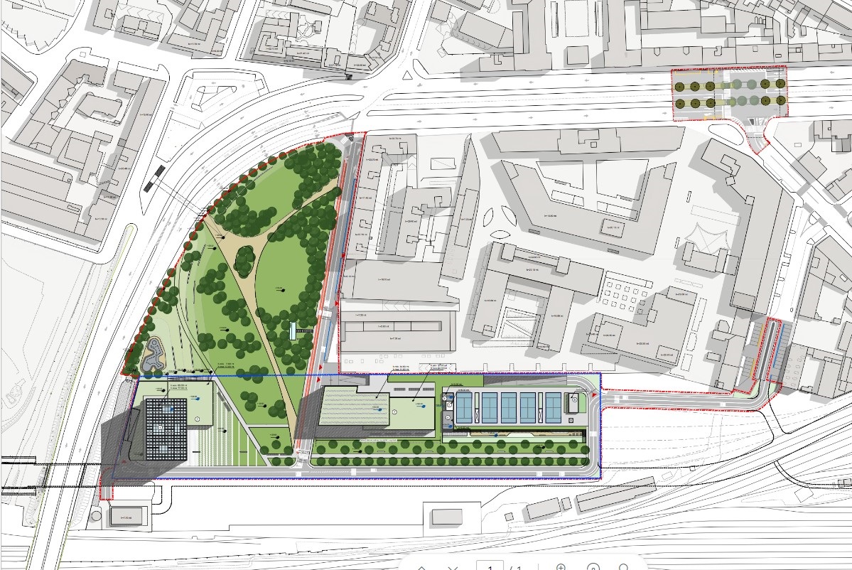
The intervention redefines the public space of the area, joining the existing garden of Piazzale Lugano with the areas of the future linear park of the Farini airport; the garden will be redeveloped by eliminating a rest area and the last stretch of the dead-end road and providing new pedestrian paths, a series of functional and attractive elements (including skate park and pump track) aimed at improving attendance and safety of the area.
The overall planivolumetric structure is articulated within the rectangular-shaped lot in which the development of three new buildings overlooking the new public space is envisaged, as well as the recovery of a pre-existing underground volume. The tertiary building near the overpass is configured as the tallest element, and rests on a podium with a green roof which will contain some compatible functions and shops near the park. The adjacent commercial building appears as a single-storey structure located in relation to the park in Piazzale Lugano. The multifunctional building (tertiary and hospitality) is located at the end of the pre-existing predominantly tertiary block.
The roofs of the commercial and multifunctional building are designed as green terraces partly intended for photovoltaic panels.
The recovery of the pre-existing underground volume to be used in part as a postal distribution center involves the arrangement of the surface part for sports services, for approx. 3.000 mXNUMX. to be agreed upon if qualified as services of general interest.
In Investigation
- Under investigation (final proposal submission date 29 May 2017, detailed by mobility theme);
- Documentary additions: 01 July 2022
The proposed Implementation Plan provides for a total SL of 23.000 m10.500. in compliance with the PGT, divided into three new buildings, divided as follows: the first of 200 m1.000. (of which 11.500 m200 for trade) intended for predominantly tertiary use), the second of XNUMX mXNUMX. for commercial use and a building for tertiary/reception use of XNUMX mXNUMX. (of which XNUMX mXNUMX for trade).
The project also rationalizes two primary postal distribution centers in this area, one of which is located in Piazzale Lugano, recovering the existing underground volume for a surface area of approx. 1.500 m1.800. to which is added an area intended for garage for service vehicles of approx. XNUMX mXNUMX. and a part reserved for private parking.
In correspondence with the underground volume, on the surface, the project identifies a sports area for approx. 3.000 mXNUMX. initially proposed as a service of general interest to be subsidized or a private service.
Regarding the open space system, the project proposal involves the transfer of approximately 8.000 m4.300. of which approx. 3.700 mXNUMX. intended for public greenery and approximately XNUMX mXNUMX. intended for traffic. With respect to the theme of mobility, the plan envisages new road and cycle-pedestrian connections, to the existing and planned network, with the future neighborhood in the Farini airport and with the Bovisa area, with the further intention of mitigating and overcoming the current " barrier” constituted by the Bacula flyover.
Gallery

Subjects:
Updated: 26/01/2024