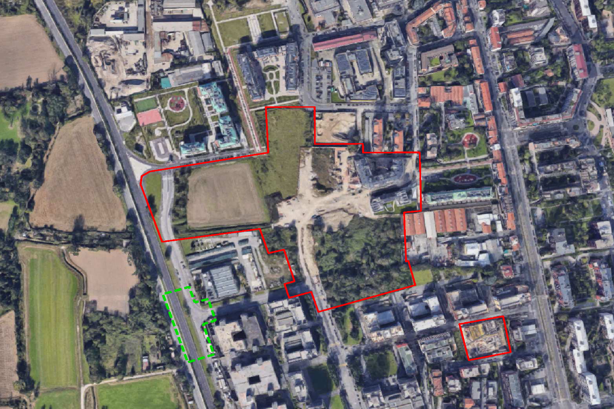
Monti Sabini, Antegnati, Amidani and A. Sforza - Integrated Intervention Programme
Monti Sabini, Antegnati, Amidani and A. Sforza - Integrated Intervention Programme
The area involved in the Integrated Intervention Program (equal to approximately 67 thousand mXNUMX) consists of the large "empty space" left unbuilt in the center of the urban area between Via Ripamonti and Via Ferrari, south of Via Antonini and on the edge of the first offshoots of the Southern Milan Agricultural Park.
The PII aims to recompose and mend the existing fabric between the transformations that occurred to the north (PII Verro Alamanni) and the buildings built at the end of the 80s to the south - in implementation of a Detailed Plan in which the area in object was included - recently the subject of refunctionalization and building recovery after years of abandonment (via Antegnati), through the inclusion of a complex system of residential destinations, the promotion of an integrated system of public services, the redevelopment and strengthening of the system of roads, the increase and redevelopment of the public open space system.
In particular, the project includes:
- the creation of a residential settlement divided into a free regime (44% of the total), and a social one (53%) in the forms of ordinary subsidized housing for sale and subsidized housing for rent, as well as residual shares (3%) of other urban functions;
- the creation of a service system along the central axis consisting of a school complex (with an adjoining gym open to the neighbourhood) and another building intended for library/multipurpose centre;
- the completion of the infrastructural network (extension of via Amidani and its connection with via Bugatto to the west, Gabussi to the south, Monti Sabini to the east and Erice to the north);
- connection of the cycle system along the north-south direction of the urban area;
- equipped green accommodation.
In progress
Section B has been completed, in Section C two out of three private buildings and part of the urbanizations have been completed;
for Section A (public) the implementation agreement will be stipulated following the sale of the building rights following a public tender (currently being prepared).
In implementation of the guidelines set with the “Ripamonti-Ferrari” Unitary Project Coordination Document (DCPU) - developed starting from 2001 to coordinate the various Integrated Intervention Programs proposed in the context - the PII provides for a planivolumetric distribution with building typologies at L", "C" or in line between 4 and 6 floors to "guard" the new local road axes and hinged on a central axis (separated into road and cycle flows) along which the new services will be located.
Subjects:
Updated: 16/01/2024

