
PGT Adopted - Milan 2030
A NEW STEP TOWARDS #MILAN2030
The Territorial Government Plan for Milan 2030 has been adopted
The City Council approved the Milan 2030 PGT in the meeting of 14/10/2019.
The new Territorial Government Plan will become effective with the publication of the notice of approval definitive version of the Plan in the Official Bulletin of the Lombardy Region (BURL), which will take place following the drafting of the documents modified by the acceptance of observations, opinions and amendments.
Until that date, the provisions continue to apply safeguard measures following the adoption of the Plan, operational starting from 05/03/2019.
Main changes made to the Plan through amendments
Addition of Abbiategrasso among the strategic squares and Bonola among the interchange nodes to be redeveloped, the new denomination of some of the 88 districts of the city - which also marks the official recognition of "Nolo" together with Loreto and Casoretto -, reduction of times, from three to two years, for a decommissioned property to be considered abandoned, the removal of the Via Novara area from the municipal areas to be put up for tender for the construction of a place of worship, the confirmation of Piazza d'Armi as a future example of urban forestation .
Allocation to other municipalities of at least 50% of the proceeds relating to urbanization charges and monetizations deriving from urban planning interventions in Municipality 1, the obligation for operators to start works of public interest before private interventions, the ban on outdoor activities wholesale in the Ancient Formation Nuclei such as via Sarpi, the objective of planting two trees for every new parking space created, the need to hold competitions or similar instruments for the regeneration projects of the squares and interchange nodes with subsequent monitoring of the effects of 'intervention.
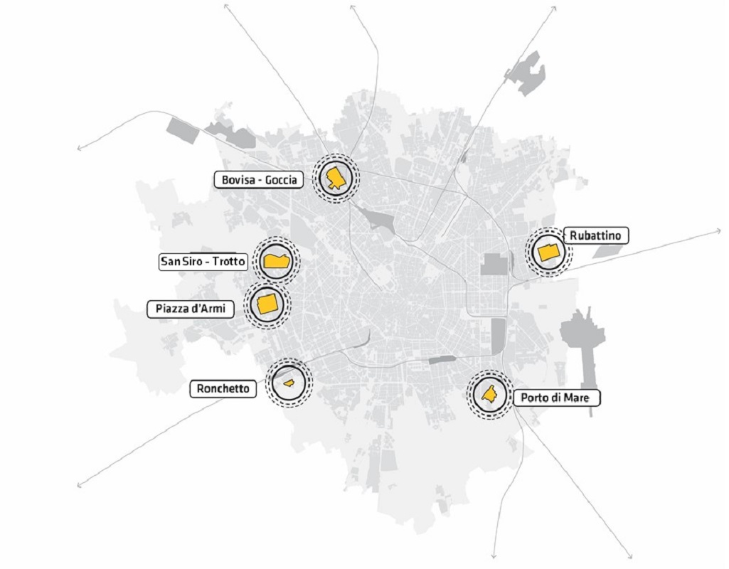
Possibility of creating large sales structures in the areas intended to host large urban functions of San Siro-Trotto, Porto di Mare and Ronchetto, in order to guarantee the financial sustainability of the GFU themselves.
Increase in the share of social residential housing in interventions of over 10.000 m0,40 of surface area, providing for an index of 0,35 m0,20/m0,20 (compared to 0,05 of the current PGT) divided into at least XNUMX mXNUMX/mXNUMX per rental, at most XNUMX mXNUMX/mXNUMX for sale and obligation of XNUMX for public residential construction in the presence of public financing.
We inform you that the SAFEGUARD MEASURES will be operational starting from 5 March 2019, the date of the adoption resolution.
Attached below are the documents of the ADOPTED PGT as amended by the City Council upon adoption.
We invite you to follow the official communication channels (News and Newsletter, Social).
1. A connected, metropolitan and global city
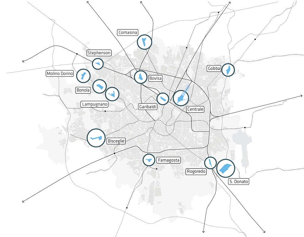
Urban planning will be strongly connected to the development of mobility infrastructures, which in the coming years will see the construction of the M4, the extension of the metro towards Monza and Settimo Milanese, the adaptation of the railway belt according to the Circle Line and the strengthening of the railway service Regional and high speed. According to an urban growth logic that wants the greatest possible number of people to live and work a short distance from a train or metro stop also to reduce dependence on private mobility, the Plan encourages regeneration interventions near 13 interchange nodes – Comasina, Bovisa, Stephenson, Cascina Gobba, Centrale, Garibaldi, San Donato, Rogoredo, Famagosta, Bisceglie, Lampugnano, Molino Dorino, Bonola – determining in correspondence with them the possibility of exceeding the maximum building index of 1 m0,7/mXNUMX foreseen in highly accessible areas of the city (the maximum index in the less accessible areas is instead set at XNUMX mXNUMX/mXNUMX) also through the creation of Social Residential Housing.
2. A city of opportunities, attractive and inclusive
The Plan identifies 6 areas - San Siro-Trotto, Bovisa-Goccia, Piazza D'Armi, Ronchetto, Porto di Mare and Rubattino - whose development will be linked to the establishment of "Large Urban Functions", such as hospitals, sports facilities, parks urban areas, administrative headquarters, large-scale projects that bring new services to the metropolitan area. It is also expected to assimilate the change of intended use between the production, tertiary, hospitality and private services categories, in order to encourage the creation of job opportunities for young people, in particular linked to the 4.0 economy. As regards the housing issue, given the growing demand of the young population, the Plan encourages the construction of rental homes, allowing private individuals to exceed the maximum buildability index in accessible areas of the city through the construction of social housing for rent, for sale of subsidized type and co-housing and reducing the request for provision of services for free building interventions, provided that a rent quota is foreseen, with the aim of increasing the offer and therefore controlling prices.
3. A green, livable and resilient city
The new Plan provides for a reduction in land consumption by 4% compared to the current Plan, to be achieved through the restriction of over 3 million m1,5 of areas to agricultural use, the expansion of the southern park by approximately 20 million m7, the creation of the large Metropolitan Park through the ecological connection between the North park and the South park, the creation of at least XNUMX new parks including the XNUMX planned within the railway yards and a forestation plan under study which provides for an increase notable number of trees in the metropolitan area.
As far as buildings are concerned, the required standards will be raised, with the improvement of energy performance, the creation of new permeable areas, including through "green roofs", and the certification of CO2 reduction.
4. One city, 88 neighborhoods to call by name
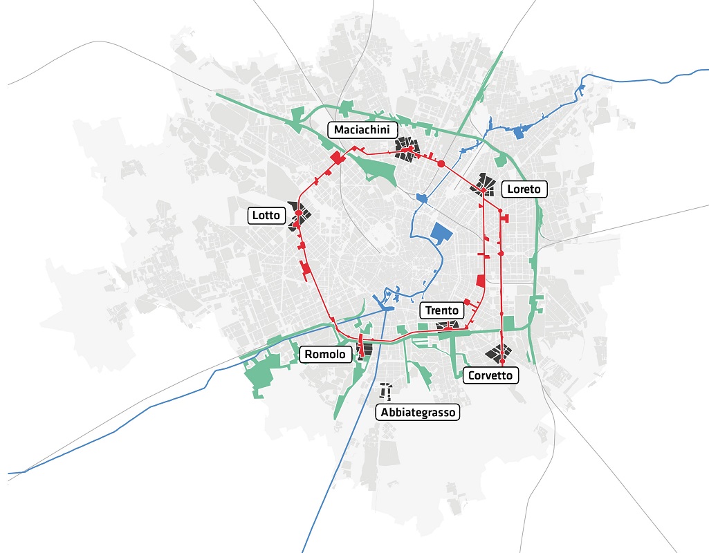
The plan aims to enhance its 88 neighborhoods by placing its squares at the centre, improving public space and services for citizens and overcoming the territorial and social gap between center and periphery. The heart of this strategy are the projects for the reopening of the Navigli, the redevelopment of the railway yards and the regeneration of 7 squares characterized by high accessibility located on the 90/91 axis; Loreto, Maciachini, Lotto, Romolo, Abbiategrasso, Trento and Corvetto can be regenerated with interventions that improve their design quality, pedestrian usability and attractiveness. Even in these areas characterized by wide accessibility it will be possible to exceed the maximum building index (1 m0,7/mXNUMX instead of XNUMX mXNUMX/mXNUMX) through the creation of Social Residential Building.
5. A city that regenerates itself
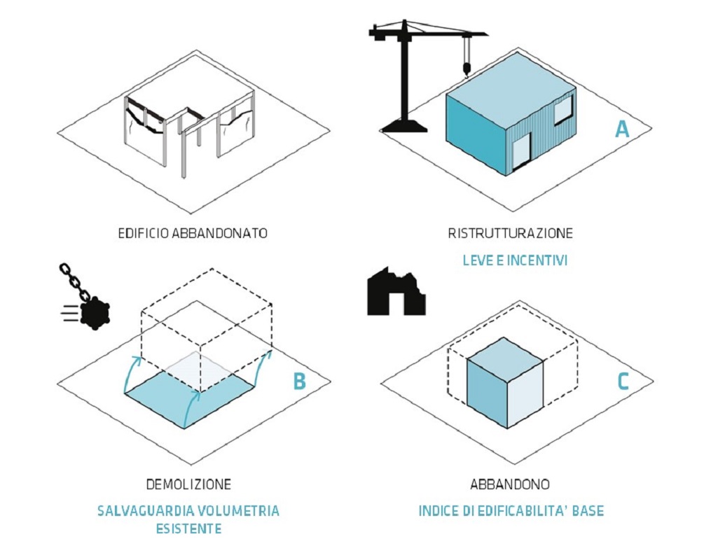
Redevelop the existing so as not to consume further public land. The Plan identifies some "Urban Regeneration Areas", areas on the edge of the territory which will have to be enhanced with interventions aimed at recovering the degraded building heritage. Furthermore, the recovery of 3 thousand public housing units is envisaged, the creation of some social rent housing within the framework of the Program Agreement on the Railway Yards, the experimentation in 10 public areas of public housing and housing services within contexts mixed social groups. Finally, severe measures are envisaged regarding abandoned buildings, providing for the loss of existing volumetric rights and the assignment only of the single building index for those who leave buildings in a state of decay.
Environmental Report
► ALL_B_VAS - Environmental Report
Environmental Report: Annex 1 Reference planning framework
► ALL_B1_VAS - Environmental Report - Annex 1
Environmental Report: Annex 2 Territorial and environmental reference framework
► ALL_B2_VAS - Environmental Report - Annex 2
Non-Technical Summary
► ALL_C_VAS_Non-Technical Summary
Reasoned opinion
► ALL_D_VAS_Reasoned_Opinion
Reasoned Opinion: Attachment 1 – Investigation Report
► ALL_D1_VAS_Motivated_Opinion_ALL1_Report
Reasoned opinion: Attachment 2 – Conference minutes
► ALL_D2_VAS_Parere_Motivato_ALL2_VerbaliConf
Reasoned Opinion: Attachment 3 – Observations/Contributions
► ALL_D3_VAS_Opinion_Motivated_ALL3_Contributions
Summary Statement
► ALL_E_VAS_Dichiarazione_di_Sintesi
Declaration of adequacy of the geological component
► ALL_F_Component_Compatibility_Declaration
Municipal opinion 1
► ALL_G_Municipio1_Del18_24.07.2018
Municipal opinion 2
► ALL_H_Municipio2_Del39_26.07.2018
Municipal opinion 3
► ALL_I_Municipio3_Del24_25.07.2018
Municipal opinion 4
► ALL_L_Municipio4_Del26_25.07.2018
Municipal opinion 5
► ALL_M_Municipio5_Del23_26.07.2018
Municipal opinion 6
► ALL_N_Municipio6_Del32_30.07.2018
Municipal opinion 7
► ALL_O_Municipio7_Del21_24.07.2018
Municipal opinion 8
► ALL_P_Municipio8_Del32_18.07.2018
Municipal opinion 9
► ALL_Q_Municipio9_Del44_26.07.2018
General Report: Milan 2030 – Vision, Construction, Strategies, Spaces
► 01DP_General_Report
Implementation rules
► 02DP_Regulations_Implementation
Table D.01 Draft Plan; scale 1:30.000
► 03DP_D01_Draft_plan
Table D.02 Map of the landscape; scale 1:20.000
► 04DP_D02_Landscape_map
Annex 1: Landscape Contents of the Plan, Municipal Ecological Network and Urban Green and Open Space System
► 05DP_DA1_Paesaggistici_REC
Implementation rules and Catalog of public services and of public or general interest
► 01PS_Norms_Implementation_Catalogue
Local Identity Units (Cards, List of services from the Catalogue)
02PS_NIL List of services
► 02PS_NIL_List_Services
02PS_NIL sheets from 01 to 15
► 02PS_NIL_Schede_01_15
02PS_NIL sheets from 16 to 30
► 02PS_NIL_Schede_16_30
02PS_NIL sheets from 31 to 44
► 02PS_NIL_Schede_31_44
02PS_Shede of NILs from 45 to 60
► 02PS_NIL_Schede_45_60
02PS_Shede of NILs from 61 to 75
► 02PS_NIL_Schede_61_75
02PS_Shede of NILs from 76 to 88
► 02PS_NIL_Schede_76_88
Table S.01 Public Services and of public or general interest; scale 1:10.000
03PS_S01/1_Servizi_sistenza_1_NO
► 03PS_S01_Municipal_public_services_1_NO
03PS_S01/2_Servizi_sistenza_2_NE
► 03PS_S01_Servizi_pubblici_comunali_2_NE
03PS_S01/3_Servizi_sistenza_3_SE
► 03PS_S01_Servizi_pubblici_comunali_3_SE
03PS_S01/4_Servizi_sistenza_4_SO
► 03PS_S01_Servizi_pubblici_comunali_4_SO
Table S.02 The urban greenery and mobility infrastructure system; scale 1:10.000
04PS_S02/1_Sistema_verde_mobilità_1_NO
► 04PS_S02_Sistema_verde_mobilita_stradale_1_NO
04PS_S02/2_Sistema_verde_mobilità_2_NE
► 04PS_S02_Sistema_verde-mobilita_stradale_2_NE
04PS_S02/3_Sistema_verde_mobilità_3_SE
► 04PS_S02_Sistema_verde-mobilita_stradale_3_SE
04PS_S02/4_Sistema_verde_mobilità_4_SO
► 04PS_S02_Sistema_verde-mobilita_stradale_4_SO
Table S.03 Ecological network and system of urban greenery and open spaces; scale 1:20.000
► 05PS_S03_Ecological_network
Implementation rules
► 01PR_Regulations_Implementation
Table R.01 Feasibility and geological, hydrogeological and seismic requirements; scale 1:20.000
► 02PR_R01_Geological_Feasibility
Table R.02 Urban planning indications; scale 1:10.000
03PR_R02/1_Urbanistic_Indications_1_NO
► 03PR_R02_Indicazioni_urbanistice_1_N-O
03PR_R02/2_Indicazioni_Urbanistic_2_NE
► 03PR_R02_Indicazioni_urbanistice_2_N-E
03PR_R02/3_Indicazioni_Urbanistic_3_SE
► 03PR_R02_Indicazioni_urbanistice_3_S-E
03PR_R02/4_Indicazioni_Urbanistic_4_SO
► 03PR_R02_Indicazioni_urbanistice_4_S-O
Table R.03 Morphological indications; scale 1:10.000
04PR_R03/1_Indicazioni_Morfologica_1_NO
► 04PR_R03_Indicazioni_morphologica_1_N-O
04PR_R03/2_Indicazioni_Morfologica_2_NE
► 04PR_R03_Indicazioni_morphologica_2_N-E
04PR_R03/3_Indicazioni_Morfologica_3_SE
► 04PR_R03_Indicazioni_morphologica_3_S-E
04PR_R03/4_Indicazioni_Morfologica_4_SO
► 04PR_R03_Indicazioni_morphologica_4_S-O
Table R.04 Nuclei of ancient formation - Analysis of historical-morphological values; scale 1:2.000
05PR_R04/1_NAF Historic centre_Analysis_1
► 05PR_R04_NAF-CS_Analisi_valori_storico-morphologico_1
05PR_R04/2_NAF Historic centre_Analysis_2
► 05PR_R04_NAF-CS_Analisi_valori_storico-morphologico_2
05PR_R04/3_NAF Historic centre_Analysis_3
► 05PR_R04_NAF-CS_Analisi_valori_storico-morphologico_3
05PR_R04/4_NAF Historic centre_Analysis_4
► 05PR_R04_NAF-CS_Analisi_valori_storico-morphologico_4
05PR_R04/5_NAF Historic centre_Analysis_5
► 05PR_R04_NAF-CS_Analisi_valori_storico-morphologico_5
05PR_R04/6_NAF Historic centre_Analysis_6
► 05PR_R04_NAF-CS_Analisi_valori_storico-morphologico_6
05PR_R04/7_NAF External nuclei_Analysis_7
► 05PR_R04_NAF-CS_7_16_Analysis of morphological historical values
05PR_R04/8_NAF External nuclei_Analysis_8
► 05PR_R04_NAF-CS_17_25_Morphological_historical_values_analysis
Table R.05 Administrative and soil protection constraints; scale 1:20.000
► 06PR_R05_Administrative_constraints
Table R.06 Protection and safeguard constraints; scale 1:20.000
► 07PR_R06_Vincoli_tutela
Table R.07 Risks, noise and Radar for air navigation; scale 1:20.000
► 08PR_R07_Airport_restrictions_part_I
Table R.08 Obstacles and Dangers for air navigation; scale 1:20.000
► 09PR_R08_Airport_restrictions_Part_II
Table R.09 Hydrographic Network - buffer zones and flood risk management plan (PGRA); scale 1:10.000
10PR_R09/1_Reticolo_idrografico_PGRA_1_NO
► 10PR_R09_Reticolo_Idrico_PGRA_1_N-O
10PR_R09/2_Reticolo_idrografico_PGRA_2_NE
► 10PR_R09_Reticolo_Idrico_PGRA_2_N-E
10PR_R09/3_Reticolo_idrografico_PGRA_3_SE
► 10PR_R09_Reticolo_Idrico_PGRA_3_S-E
10PR_R09/4_Reticolo_idrografico_PGRA_4_SO
► 10PR_R09_Reticolo_Idrico_PGRA_4_S-O
Table R.10 Land Consumption Map; scale 1:20.000
► 11PR_R10_Carta_Consumo_Soil
Annex 1: Map of the landscape sensitivity of the places; scale 1:20.000
► 12PR_RA01_Giudizio_sintetico_paesaggio
Annex 2: Regulations on hydraulic police
► 13PR_R_A2_Regulation_Hydraulic Police
Annex 3: Technical document for companies at risk of a major accident
► 14PR_A3_ERIR
Annex 4: Explanatory report and guidelines relating to obstacles and dangers for air navigation and technical information - Methodology for estimating airport noise level assessment (LVA) curves
► 15PR_RA4_Relazione_Incoli_aeroportuali_part_III
Report and implementing rules
► 01PAR_Relation_Regulations_Implementation
Table PAR.01 Existing and forecast religious equipment; scale 1:20.000
► 02PAR_Religious_Equipment_Plan
Mediagallery

Subjects:
Updated: 20/03/2020